Hiker's Blog on Corsica Island
GR 20 in April, May and November
I’m getting a lot of questions these days about walking the GR 20 trail in early spring or late autumn. People most often worry about weather, snow and lodging.
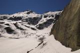
 Lake Melo in April 2006: The GR 20 trail goes in the ridge above the frozen lake.
Weather and temperatures
GR 20 is a high-level mountain path and you can predict the only thing: Weather is very unpredictable and quickly changing there in April, May or November. Be ready for temperatures around or below zero in nights. Days may be sunny and warm as well as cold and rainy. Expect dense mists and low clouds that make navigation very difficult. Strong wind is almost sure.
You can check out both up to date and historic weather conditions in many places of Corsica on the photos on Infoclimat.fr=.
Snow and ice
There is snow even in lower elevations of Corsica right now. It will probably melt soon this year, but it can lay on some places till the end of May. Some parts of the GR 20 are secured by iron chains or ladders and they are quite dangerous when covered by ice. You should not get on the route without an ice axe and crampons. Read Paddy Dillon’s advices on OutdoorsMagic.
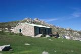
 Refuge de Prati in May 2003: The hut is already open and there is no snow around.
Refuges
PNRC refuges are open all year round for safety reasons, but they offer no services from November to May. That means you can get in to spend a night inside, but you can’t buy food and there is no heating or light there. Even the sources of drinking water may be frozen.
You can contact the Parc Naturel Regional de La Corse (PNRC) and ask them for up to date weather forecast and details about refuges.
Tel: 04 95 51 79 00
Fax: 04 95 21 88 17
E-mail: infos@parc-naturel-corse.com
Website: www.parc-naturel-corse.com (in French)
Have an alternate plan
Most of the other Corsican trails are passable in early spring or late autumn. It’s a good idea to chose one of them and have it as a backup plan when a lot of snow prevents you from walking the GR20. For instance consider Mare e Monti Nord or Mare a Mare Centre — both running through broadleaf forests that are especially beautiful in autumn — or Sentier de la Transhumance, what’s a shorter and easier version of the GR 20 trail.
Posted by Marek Prokop on Sat, 2007-03-24 13:55
Lufthansa to fly to Bastia
According to this press release Lufthansa expands its flight offering and Bastia is among its new destinations. New timetable goes into effect from March 25, 2007 and Bastia will be served from Hamburg.
I’ve tried to find a flight from Hamburg (HAM) to Bastia (BIA) on the Lufthansa website and it really works. For instance I’ve found the flight departing from Hamburg on June 2 at 11:35 and arriving to Bastia at 13:45 (back on June 9 at 14:15). The price for such roundtrip is about 430 Euro including taxes.
Related: Flights to Corsica, Getting to Corsica.
Posted by Marek Prokop on Wed, 2007-03-14 14:50
45 highest Corsican mountains
Although Corsica is often called the mountains in the sea, finding out what are the highest summits of the island isn’t that easy. Géographie de la Corse in the French Wikipedia lists just few examples. German Wikipedia comes with this top seven:
- Monte Cinto (2706 m)
- Monte Rotondo (2622 m)
- Punta Minuta (2556 m)
- Paglia Orba (2525 m)
- Monte d’Oro (2389 m)
- Monte Renoso (2352 m)
- Capu Tafunatu (2343 m)
An excellent article about Corsican mountains by Gangolf Haub on SummitPost.org states that “50 summits reach more than 2000m in elevation with Monte Cinto being the highest one.” English Wikipedia agrees with “Monte Cinto as the highest peak at 2706m,” however then mentions only “20 other summits of more than 2000m.” Where is the truth?
I took a couple of maps and made my own list of 45 peaks of Corsica that are higher than 2000 metres. The list is not complete and the real number probably exceeds 50. For instance there are at least five other peaks over 2000 m in the ridge of Monte Cinto and Paglia Orba, and another ones around Monte d’Oro. I did not include them, because they are difficult to identify exactly enough in my maps.
| # | Name | Elevation |
| 1 | Monte Cinto | 2706 |
| 2 | Monte Rotondu | 2622 |
| 3 | Capu a u Perdatu | 2583 |
| 4 | Capu Biancu | 2562 |
| 5 | Punta Minuta | 2556 |
| 6 | Capu Falu | 2540 |
| 7 | Paglia Orba | 2525 |
| 8 | Capu Larghia | 2503 |
| 9 | Monte Cardo | 2453 |
| 10 | Punta Felicina | 2437 |
| 11 | Punta Lattiniccia | 2413 |
| 12 | Monte Padru | 2393 |
| 13 | Monte d’Orro | 2389 |
| 14 | Punta da i Ciottu | 2379 |
| 15 | Monte Renosu | 2352 |
| 16 | Pietra Niella | 2345 |
| 17 | Capu Tafunatu | 2335 |
| 18 | Punta Artica | 2327 |
| 19 | Punta a e Porte | 2313 |
| 20 | Cima di a Statoja | 2304 |
| 21 | Capu a Chiostru | 2295 |
| 22 | Capu Selolla | 2273 |
| 23 | Capu a i Sorbi | 2267 |
| 24 | Monte Tortu | 2262 |
| 25 | Punta a Vetta | 2255 |
| 26 | Punta Migliarellu | 2254 |
| 27 | Punta Cappella | 2250 |
| 28 | Punta Licciola | 2237 |
| 29 | Muvrela | 2148 |
| 30 | Capu Ladroncellu | 2145 |
| 31 | Monte Corona | 2144 |
| 32 | Aiguilles Popolasca | 2180 |
| 33 | Monte Niello | 2157 |
| 34 | Monte Incudine | 2134 |
| 35 | Punta Capizzeli | 2106 |
| 36 | Punta Scaldasole | 2101 |
| 37 | Cimatella | 2098 |
| 38 | Capu Terra Corscia | 2079 |
| 39 | Punta di a Cappella | 2042 |
| 40 | Punta Capannella | 2032 |
| 41 | Capu a u Dente | 2029 |
| 42 | Punta di Pinzi Corbini | 2021 |
| 43 | Punta di Tintennaja | 2018 |
| 44 | Capu a u Tozzu | 2007 |
| 45 | Punta Renosa | 2008 |
You can explore all the summits listed above on Google Maps or download a KML file to view them on Google Earth. Please note, only the first 20 mountains are placed on the exact coordinates (using Google Earth high resolution aerial maps). Locations of the other ones may be slightly inaccurate.
Posted by Marek Prokop on Tue, 2007-03-13 12:02
Flights to Corsica from Belgium, Germany and Netherlands
I’ve updated the list of flights to Corsica, particularly the table of direct low-cost flights. New additions are:
Posted by Marek Prokop on Tue, 2007-03-06 20:25
GPS data of the GR 20 route
From now on you can download all my GPS data for the GR 20 trail and use it in your Garmin, Magelan etc. Please note they are not true tracklogs recorded by a GPS device. I created the files by hand using calibrated scanned maps and TrackMaker. Then I validated them in Google Earth and they all seem to be accurate enough. After all, my maps of GR20’s stages (e.g. this one) are based on the same data.
More GR20’s GPS data on-line
During my research I found the following GPS data of the GR 20 trail available online. I list them all, because you may find them useful:
- GR 20 at Giscover.com — GR 20 tracklog published by Guido Schmidt in September 2005. Only registered members of the Giscover.com seem to be able to download the tracklog. Other visitors can just see it on a very small Google map. The website is in Italian. Probably the same log (at least its author is Guido Schmidt again) is available without registration at GPSTracks.nl with a short description in Dutch, Google map and a KML file for the Google Earth.
- GPSTracks.nl also offers a short walk (4km) in Cirque de Bonifatu.
- A Dutch website GPS-info.nl offers a huge 400kb GR 20 tracklog for download with hundreds of waypoints.
- Michal Pasniewski published a short report of his GR20 trek done in May 2002 and included a tracklog of the GR20 in Garmin mps format.
- Plain text coordinates of the GR 20 Nord are available at E-voyageur.com. You can download a big 1.2MB file or separate stages in 9 smaller files. Another three files contains the routes to Monte Cinto from Asco, to Paglia Orba and Capu Tafunatu from Ciottulu di i Mori, and to Monte Rotondo from Petra Piana. The files are accompanied with description of the stages in French, scanned topo maps and photos.
- alpin-koordinaten.de (in German) offers six routes in multiple formats: GR20 Nord, GR20 Sud, Monte Cinto both from Asco and Haute Asco, Monte Rotondo from Petra Piana and Paglia Orba from Ciottulu di i Mori.
Posted by Marek Prokop on Wed, 2007-02-28 15:39